|
Home of the Manny
Flick Regattas,
Philadelphia City Championships, & the Stotesbury
Regatta |
 |
 |
|
Additional
Schuylkill Maps showing the
walking path,
Click HERE! |
FROM EGG HARBOR TWP, N.J.
TO SCHUYLKILL
Take the Atlantic City Expressway to the
Walt Whitman Bridge. Follow the Schuylkill
Expressway past Boat House Row, past the race
area, past Roosevelt Avenue, all the way to the
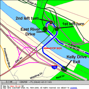
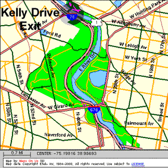
Kelly Drive Exit. It exits to the right. At
the bottom of the exit is a Stop Sign. Traffic
is one-way, so turn right. IMMEDIATELY get into
the left hand lane. Take the first left to
Ridge Avenue East/Kelly Drive. This is a tight
curve, so be careful! Stay in the left lane and
immediately bear left, following signs to Kelly
Drive South/East River Drive. If you look at
the map, you are making a big 360 degree loop to
the left. This puts you on Kelly Drive
South/East River Drive which will take you
directly to the race area. From this point it
is one(1) mile (past four(4) traffic lights).
As you reach the race area, the Fairmount Park
Police will have a road barrier erected.
Proceed slowly. Show your Parking Pass and you
can stay to the right and enter the race area.
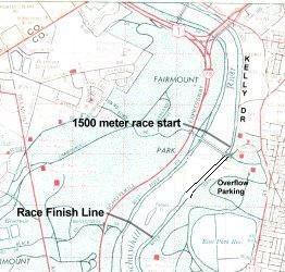
The first building on your right is the
Canoe Club (Bathrooms are in this building.
Bring your own toilet paper.). This is where
the schools park their boat trailers. Do Not
Park Here. You are just past the race start
line. Continue further down the middle of the
race course. Look for EHT Tents. Angle park
along here. Park as close as you can to the
next car to allow for maximum parking. Do
Not Park on the grass.
Hey, how do I get out
of here? About 20 minutes after the last
race, the police will start to announce over
loud speakers that all cars must leave or be
moved off of Kelly Drive into one of the parking
areas. Most of the the time, we can pack
everything up before they start towing cars.
When they do tow, they only tow to the nearest
parking area. They don't tow and ticket.
When you do leave, you must go to the
right, one way traffic only, towards Boathouse
Row. After you pass Boathouse Row, the Art
museum is on the right. Drive in front of the
Art Museum and follow the circle to the left.
On your right, you will see the sign for 676 and
the Benjamin Franklin Bridge. Take this exit.
It will put you on Vine Street to the Ben
Franklin Bridge. After you cross the Ben
Franklin bridge, you can bear to your right on
the road that takes you back toward the Walt
Whitman, then follow the North/South
Freeway(Rt.42), and the Atlantic City
Expressway.
ALTERNATE SCHULYKILL DIRECTIONS SUGGESTED BY
COOKIE CASTO:
ALLOW YOURSELF PLENTY OF TIME
FOR DRIVING [ 1 hour 20 minutes] and parking
and shuttle you need more time.
FROM EGG HARBOR TWP, N.J.
Take the Atlantic City Expressway to the Walt
Whitman Bridge.
Follow the Schuylkill Expressway past Boat House
Row, past the race area, past Roosevelt Avenue
Take exit 340 A Kelly Drive / Lincoln Drive
Exit. It exits to the right.
At the bottom of the exit is a Stop Sign.
Traffic is one-way, so turnright. IMMEDIATELY
get into the left hand lane. Take the first
left to Ridge Avenue East/Kelly Drive. This is
a tight curve, so be careful!
Stay in the left lane and immediately bear left,
following signs to Kelly Drive South/East River
Drive.
This puts you on Kelly Drive South/East River
Drive which will take you directly to the race
area. From this point it is one(1) mile (past
four(4) traffic lights). As you reach the race
area, the Fairmount Park
Police will have a road barrier erected.
Proceed slowly.
PARKING PASS ACCESS: You may only access Kelly
Drive with a Parking Pass. Show your Parking
Pass and you can stay to the right and enter the
race area.
NO PARKING PASS: You will be re-routed to
Fairmount Park. There is shuttle transportation
as well as walk paths. When taking the walk
path, be very careful. You may print out a map
of the walk paths from out website
WALK PATH MAP, directions etc.
We set up our tents mid way on Kelly drive, our
banner will be on the back side of the tents for
identification. Do not leave any valuables in or
exposed in your car!
If you get lost call my cell
609-432-1045
Thanks
Cookie
Maps
showing the
walking
path,
Click HERE!
|
|
DIRECTIONS
TO THE COOPER RIVER,
CAMDEN COUNTY PARK
CHERRY HILL, NJ |
|
 |
DIRECTIONS FROM EGG HARBOR
TOWNSHIP to BISHOP EUSTACE PARKING LOT
(Please make sure
to read Important Information at bottom of
directions.)
Directions EHT to Rt. 70 to Eustace:
-
Take the A.C. Expressway. Continue on Route
42, the North/South Freeway to I-295 NORTH
(I-295 is after the Deptford Mall just
before the Walt Whitman Bridge. It's a
right hand exit). Follow I-295 to Exit 34-B
(Cherry Hill/Route 70 West).
-
You will pass the
Barclay Shopping center on your left,
Sheraton on your right, cross over
intersection at Rt. 41 Kings Hwy.
Continue on Rt.70, passing Queen of
Heaven church on your right, car
dealerships, and a Cemetary on
your right.
-
You will then cross
through the intersection at Haddonfield
Berlin Road, passing a large shopping
center with a Wegman's. At this point
you should get into the right lane.
(Note: Bishop
Eustace will be on your left across from
Goodwill on your right.
All left turns are from right lane jug
handles.)
-
Follow the jug handle
immediately after Goodwill and cross
over Rt. 70 directly into the Eustace
parking lot.
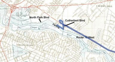
Directions EHT to Rt. 130 to Eustace:
Take the A.C. Expressway. Continue on Route
42, the North/South Freeway. bearing to the
right as you approach the Walt Whitman
Bridge. Look for Route 130 North. It's a
right hand exit.
Follow Route 130 North.
You will go through traffic lights and
around one circle. After the circle, look
on the right for the Cooper River Park.
Follow signs to Rt. 70 East.
Bishop Eustace will be on your right.
|
|
DIRECTIONS to
Mercer County Park |
|
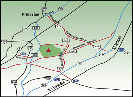 |
From Parkway
- Parkway North to Exit 58
toward Trenton/Tuckerton
- Left onto 539 N for about 22
miles
- SLIGHT LEFT onto 530 W
- Stay Straight to go to 539 N
for about 19 miles
- Turn left onto 526 N for
about 4 miles
- Turn right onto Robbinsville
Edinburgh Rd / 526 N for about 3
miles
- Turn left at Edinburgh / Old
Trenton Road (535) (this is a
T-intersection)
- "Mercer County Park"
entrance is about .2 miles on
Old Trenton Road
- Follow the park road for
about 1/2 mile until you see
regatta venue
From North and South via U.S.
1
- U.S. 1 to Quaker Bridge Road
(overpass at Quaker Bridge Mall)
- South on Quaker Bridge Road
(533)
- 2 Miles to Hughes Drive
(after third traffic light)
- Left onto Hughes (Van Nest
Wildlife Refuge near left
corner)
- Hughes to entrance on left
From New Jersey Turnpike Exit 8
- After toll, follow signs for
'Hightstown, Route 130'
- Follow road into Hightstown
until it comes to a "T" (Fire
Dept. in front of you)
- Take left at light onto Main
St.
- Follow Main St. up the hill
for about 1 mile (pass Home
Depot on left)
- At the junction of Rt. 33
and Rt. 130 veer left at traffic
light
- Follow Rt. 130 for a short
time until first light
- Take right on Hankins Rd.
- Follow Hankins Rd. for about
two miles
- Take left on Old Trenton Rd.
(traffic light)
- Follow Old Trenton Rd (go
through traffic light at
Edinburgh Rd.)
- "Mercer County Park"
entrance is about 1/2 mile after
Edinburgh Rd.
- Follow the park road for
about 1/2 mile until you see
regatta venue
From North on Route 206
- Route 206 into Princeton
- Left at traffic light by
Borough Municipal Building onto
Nassau Street
- Go 3 traffic lights to
Washington Road
- Washington Road to U.S.
Route 1 South
- Use directions for "From
North and South via U.S. 1"
|
|
|
Directions to Viking Boat House |
|
|
|
Directions to Lake Lenape |
|
-
Take Ocean Heights to Rt. 50.
Make a right at Rt. 50.
-
Make left on 13th Street (The
Hamilton Twp. Municipal Bldg. is on the corner, 6101
13th St.)
-
Continue forward until you reach
Young's Skating Center, you'll see entrance to
Lenape Lake to the left of Young's.
|
Philadelphia
Cooper River
Mercer County
Viking
Lenape
|